


 Energy


Copy
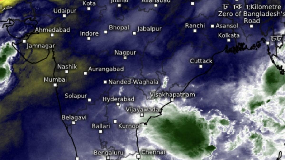
Satellite pictures show driest region where monsoon has withdrawn fully (in red and gold) forced back into extreme West Rajasthan on Tuesday as moisture and clouds (green and white) emerge from seas.
| Photo Credit:
www.meteologix.com/in
Saurashtra and Kutch in West India is likely to receive very heavy rainfall today as a well-marked low-pressure area waits in the wings to move across Gulf of Kutch during the course of the day and step out into the north-east Arabian Sea off north Gujarat, where it could regain traction and intensify back into a depression.
The system had emerged over the Bay a few days ago as a depression, and weakened into a well-marked âlow,â a status retained during its cross-country journey, a rare occurrence during monsoon end-game in September. This has blocked withdrawal process of south-west monsoon for days together, and could likely force it to further hold back over North-West India, a European Centre for Medium-Range Weather Forecasts suggests.
Rain for Konkan-Mumbai
India Meteorological Department (IMD) has predicted heavy rainfall over Konkan and Goa and Madhya Maharashtra and moderate rain/thunderstorms at most/many places during next six days; and over Saurashtra and Kutch for three days, after a spell of very heavy rain during the course of today (Tuesday).
Meanwhile, to the other side, the Bay of Bengal is witnessing a fresh churn as an incoming circulation from a South China Sea prepares to drop anchor over North Andaman Sea. It will deepen as a low-pressure area by tomorrow (Wednesday), the first day of October, by when normally the south-west monsoon exits fully.
Next low by tomorrow
Apparently, not this time round, as the IMD has forecast isolated very heavy rainfall over West Bengal on Thursday; hills of West Bengal and Sikkim on Friday and Saturday; and over Bihar on Saturday and Sunday. Other parts of Central India including Odisha; Chhattisgarh; East Madhya Pradesh; and West Madhya Pradesh may also receive thunderstorms/heavy rain as well-marked âlowâ over Arabian Sea and the Bay hum in unison.
Morning cloud cover
Satellite pictures on Tuesday morning showed heavy clouds panning out over the East Coast along Tamil Nadu and Coastal Andhra Pradesh as well as over parts of Telangana from Mannargudi; Swamimalai; Chidambaram; Cuddalore;Tiruvannamalai; Kanchipuram; Vellore; Chittoor; Chennai; Nagari; Tirupati; Rayachoti; Kadapa; Proddatur; Machilipatnam; Palakollu; Eluru; and Rajamahendravaram, among others.
Rain for South Peninsula
Isolated heavy rainfall is likely over Coastal Andhra Pradesh and Yanam for next three days with light to moderate rain/thunderstorm many/some places over the South Peninsula, as the buzz in Bay gains traction. Strong surface winds may prevail over Kerala and Mahe and Lakshadweep today (Tuesday) and for next three to four days over Tamil Nadu; Coastal Andhra Pradesh and Yanam; Rayalaseema and Telangana.
Extended rainfall?
Climate Forecast System of the US has come out with an outlook projecting extended rainfall over most parts of the country until October 8 and beyond, with next phase of organised withdrawal of monsoon resuming afresh from south-west Rajasthan and adjoining Gujarat from October 18. Indications are that north-east monsoon could unfold over the South Peninsula alongside, before propelling into an intense phase from October 29.
Please first to comment


Stay Connected
Tweets by elonmuskTo get the latest tweets please make sure you are logged in on X on this browser.